Waterfall
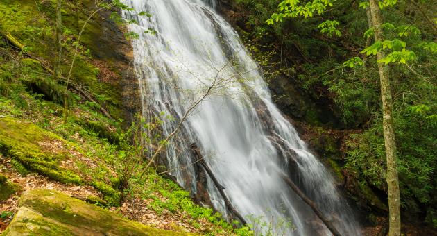
Rufus Morgan Falls
- Difficulty
- Moderate
- Distance
- .52 ml
- Duration
- .5 hr
- Ascent
- 300 ft
- Descent
- 300 ft
Forest Road 388, Franklin, NC 28734
Accessibility: Trail
Beauty Rating: 6
Photo Rating: 4
River: Left Prong Rough Fork
Watershed: Small
Type & Height: Steep, cascading slide about 65 feet high
Landowner: Landowner: Nantahala NF, Nantahala RD
Canopy: Open
Waterfall GPS: N 35.1428, W -83.5479
Best Time of Year: Jan 01 - Dec 31
Hike Description: The trail leading from the parking area is easily followed. You’ll climb via switchbacks and follow a small drainage for a short distance before crossing the branch and swinging around to cross Left Prong at 0.4 mile. After crossing, you’ll climb alongside a small sliding waterfall. The trail swings away from the creek and climbs to a sharp switchback at a junction. Turn right and climb 85 yards to the base of the falls.
On the way back, you can take the trail to the left at the junction to make this a loop hike. The trail comes out on FR 388 on the other side of Left Prong from the trailhead.
If you hike to the falls in reverse manner from the above description, you’ll cross the creek on the road, then follow the trail a few feet to a fork. The right fork follows the creek upstream. Take the left fork to reach the falls.
Overview: Born in 1885 in a log cabin in the Nantahala Mountains, Albert Rufus Morgan was a poet, conservationist, Episcopal priest, and passionate hiker. He has been called a “modern Moses” and “Uncle Rufus.” At one time, he alone maintained 50 miles of the Appalachian Trail. He also laid the foundation for Nantahala Hiking Club. Mount LeConte in the Smokies was a favorite peak of Morgan’s. He climbed it 172 times, the last time at age 92. He died on Valentine’s Day in 1983 at 97.
Start the hike to Rufus Morgan Falls in the second half of April and you may never make it there. This is among the finest spring wildflower hikes in the North Carolina mountains. Wildflowers are prolific along the entire trail and on the slope beside the falls. Watch your step if you scramble around the falls looking for photo vantage points.
I find this waterfall to be among the more difficult ones to photograph. I’ve visited many times in all seasons, but as hard as I’ve tried, I’ve yet to make a photo that does the waterfall justice. I hope you have better luck.
Directions to Location
- From the junction of US 441/23 and US 64 in Franklin, drive 3.8 miles west on US 64 and turn right on Old Murphy Road
- Go 0.2 mile and turn left on Wayah Road (SR 1310), then go 6.4 miles to the gravel FR 388, on the left
- It is 2 miles on FR 388 to a small parking area on the right just before the road crosses the creek
- FR 388 is closed in winter, typically from December 15 to March 15.
Trails and Waterfalls can be dangerous; take no chances, only photos for memories. Read our Safety and Insider tips to have a safe, fun and enjoyable trip to Jackson County.
Leave No Trace — Seven Principles
1. Plan Ahead and Prepare
2. Travel and Camp on Durable Surfaces
3. Dispose of Waste Properly
4. Leave What You Find
5. Minimize Campfire Impacts
6. Respect Wildlife
7. Be Considerate of Other Visitors
For more details, visit www.lnt.org
©1999 by the Leave No Trace Center for Outdoor Ethics
WildflowersFavorite HikeCascading slide