Motorcycle Routes
The Insider’s Guide to the Best Motorcycle Routes in the NC Mountains
The western North Carolina mountains are known for some of the most scenic motorcycle routes in the world. Whether you’re cruising America’s most celebrated motor route—the Blue Ridge Parkway—or just exploring quiet back roads, the charming mountain towns of Cashiers, Cherokee, Dillsboro, and Sylva are the perfect base camps for your motorcycling adventures.
Many riders don’t know that Jackson County offers access to the Great Smoky Mountains National Park, leisurely rider-friendly back roads, and more of the Blue Ridge Parkway than any other county in the state. Our central location also means riders enjoy less time stuck in traffic and more time exploring mountain vistas.
The following guide is “geared” toward the avid motorcyclist. From one rider to another, these are the routes our locals love best. Hop on and head to your next adventure in the western North Carolina mountains!
Disclaimer: Riding a motorcycle carries implied risks. By following this guide, you hereby release and discharge Jackson County TDA from any claims, damages, demands, or liabilities arising from injury to your person or property as the result of driving on these routes. North Carolina is a mandatory helmet state. It is always important to respect speed limits, road signs, and other motorists.
For a printable version of our guide, click here.
-
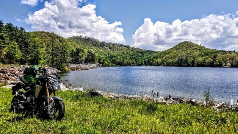
Photo by: @juiced_zDistance: 32.8 Miles Round Trip
Approximate Time: Quarter/Half-day Ride (1–2 hours by car without stops)
Difficulty: Easy
Cullowhee Mountain Road offers a true off-the-beaten path experience. Exclusive to Jackson County and recommended by local riders, this route provides riders a curvy back road excursion spanning from Cullowhee and looping around NC 107 North back to Sylva.
Directions
- Drive from Sylva on NC 107 South and follow signs for Cullowhee/Western Carolina University
- Proceed through Catamount Gap
- Pass Forest Hills on the right and proceed to the next stoplight
- Follow signs for Speedwell and take a right, passing the Jackson County Recreation Complex on the right-hand side
- Proceed to fork in the road, take the left-hand fork, following Cullowhee Mountain Rd., SR 1157
- Remain on SR 1157 for approximately 10 miles (SR 1157 makes a left turn where Cullowhee Mtn. Road dead ends into Pine Creek Road; continue left onto Pine Creek Rd. to NC 107)
- When SR 1157 intersects NC 107, turn left and proceed North on NC 107
- Remain on NC 107 for approximately 14.5 miles to return to Western Carolina University
Insider Tips
- Stop and rest at Pines Recreation Area.
1965 Pine Creek Road, Cullowhee, NC 28723
Offering 26 miles of shoreline, 3 waterfalls, and a beautiful place to rest for a while, Lake Glenville is one of the highest elevated lakes east of the Mississippi. The Pines Recreation Area amenities include a sandy swimming beach with plenty of parking for multiple bikes, restrooms, and picnic benches to eat a packed lunch.
- Cruise through Cashiers, North Carolina on your way.
6 N.C. 107, Cashiers, NC 28717
The mountain town of Cashiers, North Carolina is accessible on this route by heading south on NC 107 (right turn) for approximately 6.5 miles. Cashiers is home to upscale shopping, dining, and quaint Southern charm. It’s also home to The Village Green, a relaxing commons/park area worth exploring.
- Beware of gravel driveways.
Proceed with caution on this route. Many driveways along both Cullowhee Mountain Road and NC 107 are unpaved, and gravel will occasionally wash out into the road.
-
Distance: 69.8 Miles Round Trip
Approximate Time: Half-day Ride (2 hours by car without stops)
Difficulty: Easy to Moderate
The Great Smoky Mountains National Park offers an ideal opportunity for a half-day cruise with convenient amenities nearby. Nestled in the middle of US 441 is the Newfound Gap Overlook, located on the North Carolina-Tennessee line. This area offers abundant parking, wonderful views, hiking trails, and restrooms.
Directions
- Heading from Sylva, follow signs for US 74 W toward Cherokee, approximately 15 miles
- Take exit 74 and head North on US 441 to Cherokee
- Travel approximately 4.5 miles to US 19
- Take a right at the stoplight onto US 19 N for 0.6 miles
- Take a left at the stoplight onto Tsali Blvd, US 441 S
- Remain on US 441 S for 19 miles
- Look for Newfound Gap on the right
Insider Tips
- Explore the North Carolina side of the Great Smoky Mountains National Park (GSMNP).
The North Carolina side offers a less crowded GSMNP experience. Considering the Great Smokies is one of the most visited parks in the world, the North Carolina side offers a more relaxing experience for riders with less traffic and more cruising.
- Visit Clingmans Dome for a great view.
The turn-off to Clingmans Dome is on the left, approximately one mile before the Newfound Gap Overlook. Clingmans Dome is the highest point in the Great Smoky Mountains National Park, towering at 6,643 feet. On clear days, you can see a distance of over 100 miles throughout the Great Smokies.
- See Blue Ridge Parkway and the Great Smoky Mountains National Park in the same ride.
Conveniently, Cherokee offers a terminus for both the Blue Ridge Parkway and the Great Smoky Mountains National Park within a quarter-mile of each other. Depending on personal preference, both of these roads can be ridden on the same day in a loop.
-
Distance: 57 Miles Round Trip
Approximate Time: Half-day Ride (1–3 hours by car without stops)
Difficulty: Moderate to Difficult
The Blue Ridge Parkway is America’s most celebrated motor route for good reason. This motorcyclist mecca offers scenic views, curvy roads, and beautiful overlooks. Jackson County is home to more of the Blue Ridge Parkway than any other county. This route allows riders to get the most out of this pristine ride. The following route is designed to begin from Sylva/Dillsboro and end in the same location.
Directions
- Heading from Sylva, follow signs for US 74 W toward Cherokee for approximately 15 miles
- Take exit 74 and head North on US 441 to Cherokee
- Head approximately 4.5 miles to US 19
- Take a right at the stoplight onto US 19 N for 0.6 miles
- Take a left at stoplight onto Tsali Blvd, US 441 S
- Follow signs for Blue Ridge Parkway
- Take a right onto the Blue Ridge Parkway
- Head north on Blue Ridge Parkway for 25.5 toward Balsam Gap
- Follow signs for US 23 S/US 74 W/ Great Smoky Mountains Expressway Sylva
- Turn right onto US 23 S/US 74 W/ Great Smoky Mountains Expressway
- Remain on US 23 S/US 74 W/ Great Smoky Mountains Expressway for 10.7 miles
- Take exit 83 toward Sylva
Insider Tips
- Look at these overlooks!
Along this route there are 22 overlooks, each offering a unique view of the Blue Ridge Mountains. Among them is Waterrock Knob, which provides an ideal place for riders to rest and have a picnic. Waterrock Knob’s amenities include restrooms, a gift shop, a large parking area, picnic benches, and just a short hike to one of the highest points and best views along the Blue Ridge Parkway.
- Take the Great Smoky Mountains National Park & Blue Ridge Parkway tour.
To turn this into a full-day ride, combine both the GSMNP Newfound Gap route with the Blue Ridge Parkway route. But make sure you’re stocked up on supplies and fuel as there are no restaurants or gas stations along this route. If either is needed, proceed back to Cherokee before continuing onto the Blue Ridge Parkway portion of this ride.
-
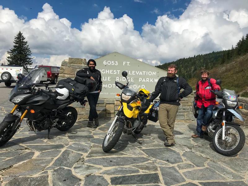
Photo by: @blisteredbrainsDistance: 106 Miles Round Trip
Approximate Time: Half-day Ride (2 hours and 36 minutes by car without stops)
Difficulty: Moderate to Difficult
This loop will take you from Sylva to Cherokee—and everywhere in between! Starting and ending in Sylva, riders will experience the best of the Blue Ridge Parkway, with some backroad farmlands and even the option to explore Harrah’s Cherokee Casino.
Directions
- Heading from Sylva, follow signs for US 74 East towards Waynesville
- Follow for 10.7 miles
- Turn left onto Blue Ridge Parkway
- Follow Parkway north for 29.5 miles
- Follow Blue Ridge Parkway to US 276 N
- Turn right onto NC 215 N Lake Logan Rd. (follow signs for Canton)
- Follow for 15.1 miles
- Merge left onto Edwards Cove Rd. for 1.6 miles
- Turn left onto US-276 N Pigeon Rd. for 4.6 miles
- Turn right at the first cross street onto S Main St for 0.3 miles
- Turn left onto Walnut St. for 0.3 miles
- Continue onto US-276 N/Russ Ave for 2.2 miles
- Use the left two lanes to merge onto US 19 S/Dellwood Rd. for 6.5 miles
- Head west on US-19 S/Soco Rd. for 16.2 miles
- Turn left onto US 441 S for 4.9 miles
- Merge left onto US 74 E/Great Smoky Mountains Expressway (follow signs for Sylva)
- Follow US 441 S and US 74 E/Great Smoky Mountains Expressway for 9.5 miles
- Take exit 83 for Sylva
Insider Tips
- Visit the Wheels Through Time Museum.
62 Vintage Lane Maggie Valley, North Carolina 28751
Home to the world’s premier collection of rare American motorcycles, memorabilia, and a distinct array of “one-off” automobiles, the Wheels Through Time Museum is a must-see. Operating hours are Monday–Thursday from 9am–5pm.
- Find the best Blue Ridge Parkway views heading north.
Riding on the Blue Ridge Parkway (BRP) gives riders the opportunity to see some truly spectacular views along the way. With many named pull-offs along this route, riders are encouraged to check out Cowee Mountain Overlook, Richland Balsam, and Devil’s Courthouse. Richland Balsam is the highest point along the BRP standing at 6,053 feet, and it’s a rider favorite thanks to the great photo opp. Cowee Mountain Overlook offers a fully panoramic view and is one of the best places to catch a sunset in the NC mountains. The Devil’s Courthouse provides a great opportunity to stretch your legs and hike a short trail to an amazing view.
-
Photo by: @rustybagger24Distance: 57 Miles to and 11 miles on (136 miles)
Approximate Time: Full-day Ride (2.5 hours by car without stops)
Difficulty: Difficult
Known as America’s favorite two-lane touring road, the Tail of the Dragon boasts 318 curves in 11 miles, making it an extremely memorable ride. This road is located just over an hour’s drive from Jackson County, offering a full day’s experience to riders who dare take on this technical motoring experience.
Directions
- Leaving Sylva, head onto US 74 W/Great Smoky Mountains Expressway for 9.6 miles
- Keep left to continue on US 74 W for 15.2 miles
- Turn right onto NC 28 N for 31.9 miles
- Destination is on left; follow signs for Deals Gap 129
Insider Tips
Please note: Curves are incredibly sharp. Heed posted warning signs at all times. Stay in your lane, do not pass, and do not exceed posted limits.
- Say cheese!
Motorists taking on the Tail of the Dragon route are photographed by Killboy.com. Photographers are set up at various corners on the road, and pictures are available for purchase online the day after your ride.
- End your ride on a high note.
Riders will find a wide variety of comfortable accommodations and dining options upon returning to Jackson County after a day’s ride. From biker-friendly bars to elevated farm-to-table restaurants and over 120 beers on tap at local breweries, it’s the perfect end to a perfect day.
-
Scenic Jackson turns a Parkway experience into a scenic loop that winds back to Sylva through eastern Jackson County via Charleys Creek Road (S.R. 1756). This route crosses five tributaries of the Tuckasegee River’s East Fork – Tanassee Creek, Wolf Creek, Gage Creek, Charleys Creek and Sols Creek and offers pastoral scenes as well as mountain views. Landmarks along the way include Richland Balsam, the highest point on the Blue Ridge Parkway; a glimpse of 5,574-foot Charley Bald and Balsam Lake, which is the site of a U.S. Forest Service picnic area with public restrooms.
Distance: 67.3 Miles
Approximate Time: Half-day ride (1 hour and 48 minutes by car without stops)
Difficulty: Difficult
Directions:
- Heading from Sylva, follow signs for U.S. 74 East towards Waynesville
- Follow for 10.7 miles
- Turn left onto Blue Ridge Parkway N Towards Asheville
- Follow for 19.6 Miles
- Turn left onto the NC-215 ramp
- Follow NC-215 S for 3.3 miles (follow signs for Rosman)
- Turn right onto Explorer Rd (S.R. 1756, becomes Charleys Creek Rd) for 6.9 miles
- Turn right onto NC-281 N for 12 miles
- Arrive Downtown Sylva
-
Photo by: @christicarpenter_Distance: 162 Miles Round Trip
Approximate Time: Full-day Ride (4 hours by car without stops)
Difficulty: Difficult
Adding to the classic Tail of the Dragon, the Explorer loop will take you through two states and the Great Smoky Mountains National Park, making it a journey you won’t soon forget. This route is recommended by local riders as a full-day loop.
Directions
- Merge onto US 74 W/Great Smoky Mountains Expressway for 9.5 miles
- Take Exit 74 onto 441 North, continue for 4.9 miles
- Use the right two lanes to turn right onto US 19 N/U.S. 441 N
- Turn right to continue onto US 441 S for 44.5 miles
- Turn left onto Fighting Creek Gap Rd. for 12.5 miles
- Continue straight onto Little River Gorge Rd/Old State Hwy. 73 Scenic to US 321 S. for 4.8 miles
- Turn right onto Weaver Cove Gap Rd. for 1.4 miles
- Continue onto Line Springs Rd. for 1.4 miles
- Turn left onto US 321 S for 13.2 miles (turns into E Lamar Alexander Pkwy)
- Use the left lane to take the exit toward Foothills Parkway Section 8G/Foothills Pkwy W for 16.8 miles
- Turn left onto US 129 S for 15 miles
- Head south on US 129 S toward NC 28 S
- Turn left on US 28 S for 31.9 Miles
- Turn left onto US 19 N/U.S. 74 E for 5.2 Miles
- Keep left to continue on US 74 E/Great Smoky Mountains Expressway for 19.2 Miles
- Take Exit 83 to return to Sylva
-
Distance: 65.8 Miles Round Trip
Approximate Time: Half-day Ride (2 hours by car without stops)
Difficulty: Moderate
Jackson County is home to several picturesque lakes, and this route will take you past three of the region’s best: Wolf Lake, Lake Toxaway, and Lake Glenville. This route makes for a relaxing and scenic half-day ride.
Directions
- Beginning in Sylva, head South on NC 107
- Remain on NC 107 S for 12.7 miles
- After passing Dollar General Store on the left, turn left onto NC 281 S
- Remain on NC 281 S for 24.5 miles
- Turn right on US 64 W
- Remain on US 64 W for 12.7 miles
- At the Cashiers Crossroads, turn right onto NC 107 N
- Remain on NC 107 N for 26.8 miles to return to Sylva
Insider Tips
- Pack a lunch!
This route is a true half-day route. Considering the route’s secluded nature, local riders recommend packing a lunch or a snack to enjoy along the way. There is a gas station near the NC 107/NC 281 intersection but no other gas stations before reaching Cashiers.
-
Distance: 59.6 Miles Round Trip
Approximate Time: Half-day Ride (1.5 hours by car with no stops)
Difficulty: Moderate
This spin on a regional classic is a shortened version of US 28’s the Moonshiner. Giving riders a good variety of curvy backroads, highway, and scenic views, the Mini Moonshiner Loop makes for a great half-day ride.
Directions
- Heading from Sylva, merge onto US 23 BUS/US 441 S
- Remain on US 23 Business/US 441 S for 13.7 miles
- Turn right onto Sanderstown Rd.
- Remain on Sanderstown Rd. for 3.2 miles
- Turn right onto NC 28 N Bryson City Rd.
- Remain on NC 28 N Bryson City Rd. for 12.5 miles
- Follow NC 28 N and US 74 E Great Smoky Mountains Expressway
- Remain on US 74 for 25.1 miles
- Take Exit 83 for Sylva
-
Distance: 141 Miles Round Trip
Approximate Time: Full-day Ride (3.75 hours by car without stops)
Difficulty: Moderate to Difficult
This route is among the longest routes, taking riders through Sylva, Cashiers, Brevard, the Blue Ridge Parkway, Maggie Valley, and Cherokee. It contains a little of everything and can be modified to fit the rider’s preferences. This route is considered a full-day route and has multiple twisty back roads, mountain passes, and scenic vistas along the way.
Directions
- Leaving Sylva, follow NC 107 and head south toward Cashiers for 27.6 miles
- Once in Cashiers, take a left at the Crossroads onto US 64 E for 28.2 miles
- Once in Brevard, head northeast on US 64 E/ S Broad St. toward E. Main St for 3.4 miles
- Turn left onto US 276 N for 49.1 miles
- Turn right onto Raccoon Rd. to Waynesville for 3 miles
- Continue onto Ratcliff Rd. for 0.5 miles
- At the traffic circle, take the third exit for Bus 23/Asheville Rd
- Continue onto Asheville Rd. for 0.3 miles
- Continue onto N. Main St for 0.4 miles
- Continue straight onto Walnut St. for 0.3 miles
- Turn right onto US 276 N/Russ Ave. for 2.2 miles
- Use the left 2 lanes to turn left onto US 19 S/Dellwood Rd. for 23.7 miles
- Continue to follow US 19 S
- Passing Harrah’s Cherokee Casino on right, take a left at the second light onto Casino Trail
- Continue onto Casino Trail for 0.8 miles
- At the light, take a left onto US 441 S
- Continue onto US 441 S for 3.6 miles
- Use the left lane to merge onto US 74 E/Great Smoky Mountains Expressway for 9.5 miles
- Take exit 83 to return to Sylva
-
Distance: 126 Miles Round Trip
Approximate Time: Full-day Ride (3.25 hours by car without stops)
Difficulty: Moderate to Difficult
Turn this local favorite into a full-day ride! Recommended by local riders, this loop will take you past one of the highest waterfalls east of the Rockies (Whitewater Falls), through Southern Jackson County, and into South Carolina.
Directions
- Follow NC 107 S toward Cashiers for 27.6 miles
- Continue on NC 107 S to Tamassee for 9.1 miles
- Turn left onto SC State Rd. S-37-413 for 2.2 miles
- Sharp right onto SC-130 S/Whitewater Falls Rd. for 9.4 miles
- Turn left onto SC-11 N/Cherokee Foothills Highway for 12.1 miles
- Turn left onto SC State Rd. S-39-118 for 2.1 miles
- Turn left onto US 178 W/Brevard Highway for 5.7 miles
- Head north on US 178 W/Brevard Highway toward Rocky Bottom Church Rd. for 9.1 miles
- Turn left onto Main St (Rosman) for 0.2 miles
- Turn left onto US 64 W for 19.9 miles
- Turn right at the Cashiers Crossroads onto NC 107 N for 27.6 miles
Insider Tips
- Hike to Whitewater Falls.
Upper Whitewater Falls starts with a half-mile walk (relatively flat and well worth it) to one of the tallest waterfalls east of the Rockies. To access the falls, instead of taking a sharp right onto SC-130, turn left onto Whitewater Falls Road and proceed roughly half a mile to an unnamed road to the right. The parking area is large and offers restrooms and a picnic area to eat a snack or packed meal.
- Stop and rest in Cashiers.
When US 64 intersects with NC 107, you’ll be greeted by the beautiful mountain town of Cashiers, North Carolina. Cashiers is home to upscale shopping, dining, and quaint Southern charm. It’s also home to The Village Green, a commons/park area worth exploring. And be sure to check out Whiteside Brewing for great food and brews!
-
Riding in western North Carolina means that riders may experience a variety of unexpected weather conditions. We’ve compiled a list of some of the best places to wait out the storm during your ride:
East LaPorte: Located in Tuckasegee along Highway 107, East Laporte Park has a large pavilion and seating area for any group. Restrooms are also available. East Laporte is located about one mile from Western Carolina University on the right-hand side, heading south on NC 107.
Cullowhee Recreation Department: The Cullowhee Recreation Department Complex offers several covered pavilions to choose from, a large parking area, and restrooms. This location is approximately a quarter mile past Western Carolina University. Take a right onto Cullowhee Mountain Road and it’s located immediately on your right!
Mark Watson Park: Located in Sylva, Mark Watson Park offers a large pavilion with multiple picnic benches, a large area to sit, and restrooms. It’s nestled between Dillsboro and Sylva on the other side of the Jackson County Historic Courthouse on West Main St.
-
When on the road, it’s crucial to know where you can get trusted maintenance services. We’ve compiled a list of regional repair and service shops that can help you get back on the road.
Smoky Mountain Indian Motorcycle at Smoky Mountain Steel Horse →
With so many routes in and around Jackson County, why not stay in the center of the action? Whether you’re looking for a hotel or a cozy cabin, there’s no shortage of accommodations. Order a Visitor Guide today to learn more about all the adventures Jackson County has to offer, and start planning your trip today!
Plan Your Visit
Whether you’re looking to explore the great outdoors, experience Appalachian arts and culture, or simply relax in a secluded cabin, Jackson County has it all.


