Hiking
Pinnacle Park Trail
- Difficulty
- Difficult
- Distance
- 7 ml
- Duration
- 4 hr
- Ascent
- 3000 ft
- Descent
- 3000 ft
2110 Fisher Creek Rd, Sylva, NC 28779
Best Time of Year: Mar 01 - Nov 30
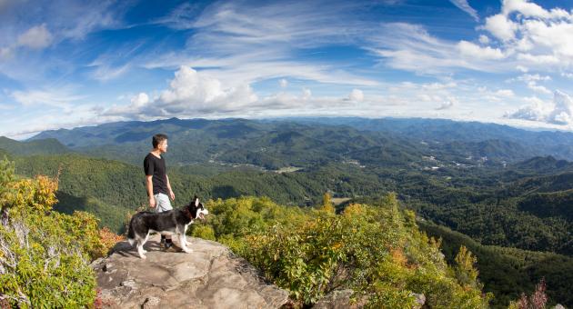
A 7-mile trek ascending more than 3000 feet, offering incredible views of the mountains from the top.
Directions to Location:
- From downtown Sylva, turn left onto Business 23 (Asheville Highway) at its intersection with NC 107.
- Turn left again onto Skyland Drive at McDonald’s.
- Continue east on Skyland approximately 2.6 miles and turn left onto Fisher Creek Road (SR 1446).
- Continue about 2.1 miles until the road ends at Pinnacle Park’s gravel parking area.
Trails and Waterfalls can be dangerous; take no chances, only photos for memories. Read our Safety and Insider tips to have a safe, fun and enjoyable trip to Jackson County.
Leave No Trace — Seven Principles
1. Plan Ahead and Prepare
2. Travel and Camp on Durable Surfaces
3. Dispose of Waste Properly
4. Leave What You Find
5. Minimize Campfire Impacts
6. Respect Wildlife
7. Be Considerate of Other Visitors
For more details, visit www.lnt.org
©1999 by the Leave No Trace Center for Outdoor Ethics
Pinnacle Park Trail FAQ
How hard is the Pinnacle Park Trail?
Difficult. It's a 7-mile round-trip trek ascending more than 3,000 feet, with a typical duration of about 3–4 hours. The Sylva-owned park's trails rank among the most challenging in Western North Carolina.
Where is the Pinnacle Park trailhead?
2110 Fisher Creek Rd, Sylva, NC 28779. From downtown Sylva, turn onto Business 23 (Asheville Highway), left onto Skyland Drive at McDonald's, continue about 2.6 miles, then left onto Fisher Creek Road for about 2.1 miles until it ends at the gravel parking area.
What's the best time of year to hike Pinnacle Park?
March through November. Winter conditions at elevation make the trail riskier outside that window.
What's the best time of day to hike Pinnacle Park?
During summer months, it's best to start early in the day before it gets warm.
What do you see from the top of Pinnacle Park?
Incredible mountain views. The park covers 1,500 acres with elevations exceeding 5,000 feet above Sylva.
How long does the Pinnacle Park hike take?
Plan on about 4 hours of moving time for the 7-mile round-trip route with 3,000 feet of climbing, longer if you linger at the summit.
Any tips for hiking the Pinnacle?
Be sure to let others know when you plan to be back. Pack snacks and plenty of water as you'll be hungry. A picnic lunch is recommended because by the time you reach the top you'll be hungry. Take your time and enjoy the nature along the way. Avoid stepping off the trail to minimize erosion and keep the trails in good shape. Also, once you reach the top, be sure to go through the rhododendrons to the left to see the panoramic view and the actual Pinnacle rock face.
Is there parking at Pinnacle Park?
Yes, a gravel parking area at the end of Fisher Creek Road.
Who owns Pinnacle Park?
The town of Sylva owns the 1,500-acre park, a rarity for a town of its size.
Are dogs allowed on the Pinnacle Park Trail?
Leashed dogs are allowed at Pinnacle Park. Please keep them on the trail to avoid any wildlife encounters.
Is the Pinnacle Park Trail safe for beginners?
It's best suited to fit, experienced hikers given the distance and 3,000-foot climb. Beginners have easier options across Jackson County's trail network, and everyone should review the county's safety and insider tips before going.
Is there water on the trail?
There are creeks on site, but it is best to bring a reusable water bottle filled with water. Remember to Leave No Trace – and leave things better than you found them.
Can you camp at Pinnacle Park?
Yes, there are designated campsites for camping at Pinnacle Park. A permit is required and is free, and you can fill it out at the trailhead.
Mountain ViewsAscent