Waterfall
Mingo Falls
- Difficulty
- Moderate
- Distance
- .2 ml
- Duration
- .25 hr
- Ascent
- 120 ft
- Descent
- 120 ft
Mingo Falls Trailhead, Big Cove Road, Cherokee, NC 28719
Accessibility: Trail
Beauty Rating: 9
Photo Rating: 10
River: Mingo Creek
Watershed: Small
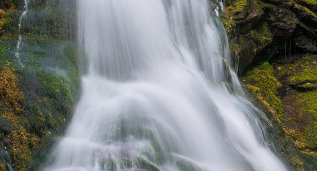
Type & Height: Near-vertical cascade with free-falling sections; the total height is over 150 feet
Landowner: Qualla Boundary, Eastern Band of Cherokee Indians
Waterfall GPS: N 35.5320, W -83.2754
Best Time of Year: Jan 01 - Dec 31
Directions to Trailhead: From the junction of the Blue Ridge Parkway and Newfound Gap Road (US 441) in the Smokies, drive south (toward Cherokee) on Newfound Gap Road for 0.5 mile and turn left on Saunooke Bridge Road. Go 0.2 mile to where the road ends at Big Cove Road and turn left. (Both Big Cove Road and Newfound Gap Road lead a short distance to Cherokee, so you can use either if you’re coming from that direction.) Drive 4.7 miles on Big Cove Road and turn right into Mingo Falls Campground. The parking area for the falls is straight ahead.
Hike Description: An obvious trail starts from the parking area and climbs the bank via 158 steps. It then levels off for the second half of the distance to the falls.
Overview: Mingo Falls has a quality that makes it a favorite for many waterfallers, and especially photographers. It falls over countless little ledges that break up the flow and create terrific opportunities for shooting isolation photos. In fact, you won’t find a better waterfall in the state for shooting this type of image. It makes a good wide-angle shot as well. You can view and photograph it well from the footbridge at the base.
I always assumed Mingo Falls was named by the Cherokees. Not only does the name sound Indian, but I’m old enough to remember the screen name of Fess Parker’s Cherokee sidekick on the Daniel Boone TV show. However, Cherokee elder Jerry Wolfe tells a different story, as quoted in Cherokee Heritage Trails Guidebook. Wolfe says the waterfall was named by loggers from West Virginia, who thought it resembled a Mingo Falls in that state. Wolfe also states that the Cherokees already had a name for the falls. They called it Big Bear Falls.
Mingo Falls is popular and its viewing area small. If you don’t like rubbing elbows when you view waterfalls, you’d better visit early in the morning.
Directions to Location
- From the junction of the Blue Ridge Parkway and Newfound Gap Road (US 441) in the Smokies, drive south (toward Cherokee) on Newfound Gap Road for 0.5 mile and turn left on Saunooke Bridge Road
- Go 0.2 mile to where the road ends at Big Cove Road and turn left
- (Both Big Cove Road and Newfound Gap Road lead a short distance to Cherokee, so you can use either if you’re coming from that direction.) Drive 4.7 miles on Big Cove Road and turn right into Mingo Falls Campground
- The parking area for the falls is straight ahead.
Trails and Waterfalls can be dangerous; take no chances, only photos for memories. Read our Safety and Insider tips to have a safe, fun and enjoyable trip to Jackson County.
Leave No Trace — Seven Principles
1. Plan Ahead and Prepare
2. Travel and Camp on Durable Surfaces
3. Dispose of Waste Properly
4. Leave What You Find
5. Minimize Campfire Impacts
6. Respect Wildlife
7. Be Considerate of Other Visitors
For more details, visit www.lnt.org
©1999 by the Leave No Trace Center for Outdoor Ethics
PhotogenicHigh WaterfallNear-vertical Cascade