Waterfall
Wardens Falls
- Difficulty
- Moderate
- Distance
- 1.68 ml
Accessibility: Trail
Beauty Rating: 5
Photo Rating: 7
River: Tuckasegee River
Watershed: Medium
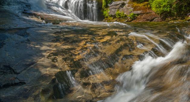
Type & Height: Steep, sliding falls about 35 feet high
Landowner: Nantahala NF, Nantahala RD
Canopy: Open
Waterfall GPS: N 35.1720, W -83.0063
Best Time of Year: Apr 16 - Apr 16
Directions to Trailhead: See the Panthertown Valley introduction for directions to the Cold Mountain Gap trailhead, on the east side.
Hike Description: Take the trail to the right of the information kiosk and follow it 0.15 mile to the old dirt road. Turn left on the road. You’ll go on a moderate descent for about 0.9 mile to a trail intersection at a small, level clearing. You’ll pass some side paths along the road, some cutting the switchbacks and one leading down to the top of Schoolhouse Falls. Stay on the main road.
At the intersection, Panthertown Valley Trail (#474), which you followed to reach this point, goes straight ahead and crosses a footbridge over Greenland Creek. The trail to Schoolhouse Falls is on the other side of the bridge. For Wardens Falls, take Devils Elbow Trail (#448), which goes right on the grassy path.
Devils Elbow Trail follows a mostly easy course for about 0.4 mile, where it passes under a power line. Unfortunately, this isn’t the last time you’ll see this eyesore. At 0.1 mile from the power line, the trail swings right around a broad ridge. There is a little clearing here with a campfire ring in it. An obvious side path goes left. Take this path. You’ll descend 0.15 mile to the Tuckasegee River. The path comes out right at the top of Wardens Falls. You won’t see anything of the falls from here, and it’s not a good idea to get into the river at the top of a waterfall. However, you’d have to cross here to reach the trail on the other side of the river, as shown on Burt Kornegay’s map. To reach the base of the falls, you don’t need to cross. Follow the obvious path that goes downstream on river right for about 100 yards. Once at the base, you still won’t be able to see the waterfall well without wading across the river to the rocks below. I’ve never seen the water low enough for a dry crossing.
Overview: See the Panthertown Valley introduction for general information about the area.
This is a neat waterfall that has one big drawback, in my opinion. The high-voltage transmission line runs right across the top of the falls. So much for a wilderness experience. The best view of the waterfall is from the rock ledge facing the falls. You can climb on the ledge without much trouble if the rocks are dry, but don’t try it if they’re wet. Also, be careful not to disturb the Michaux saxifrage and other plants growing on the ledge.
From the ledge, you can photograph the falls fairly well without including the power line. If you shoot from right at the base, you’ll have to crop tightly across the top of the falls to exclude it.
According to Burt Kornegay, the name Wardens Falls originated after a lumber company warden mysteriously drowned in the pool below the falls. Jim Burrell was a local resident in the early days.
Trails and Waterfalls can be dangerous; take no chances, only photos for memories. Read our Safety and Insider tips to have a safe, fun and enjoyable trip to Jackson County.
Leave No Trace — Seven Principles
1. Plan Ahead and Prepare
2. Travel and Camp on Durable Surfaces
3. Dispose of Waste Properly
4. Leave What You Find
5. Minimize Campfire Impacts
6. Respect Wildlife
7. Be Considerate of Other Visitors
For more details, visit www.lnt.org
©1999 by the Leave No Trace Center for Outdoor Ethics