Waterfall
Jawbone Falls
- Difficulty
- Moderate
- Distance
- 2.2 ml
- Duration
- 1.5 hr
- Ascent
- 500 ft
- Descent
- 500 ft
Cold Mountain Gap Trailhead, Cold Mountain Road, Lake Toxaway, NC 28747
Accessibility: Trail
Beauty Rating: 5
Photo Rating: 7
River: Tuckasegee River
Watershed: Medium
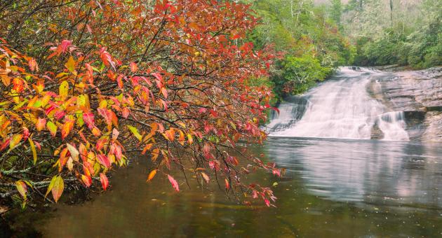
Type & Height: Long, steep slide into a large pool
Landowner: Nantahala NF, Nantahala RD
Canopy: Open
Waterfall GPS: N 35.1737, W -83.0035
Best Time of Year: Jan 01 - Dec 31
Directions to Trailhead: See the Panthertown Valley introduction for directions to the Cold Mountain Gap trailhead, on the east side.
Hike Description: Hike as you would to Wardens Falls, but continue to the right on Devils Elbow Trail when you get to the small clearing beyond the power line. At 0.13 mile from the clearing is a side path on the left. This path descends less than 0.1 mile to the river, then follows the river a short distance downstream to the top of the falls. Don’t go that way, though, as there is no view of the waterfall and no trail leading to the base. Instead, continue on the main trail (an old logging grade). At about 0.25 mile from the side path is an easy crossing of Little Green Creek. At 0.14 mile farther, you’ll reach a fork. The right fork is the route to Elbow Falls and Red Butt Falls. Take the left fork, which is Riding Ford Trail (#450), and descend about 0.1 mile to the river.
The trail comes out at the top of Riding Ford Falls. To reach Jawbone Falls, walk along the rock to the left for a few feet to an obvious path, follow it up the bank to a campsite, then bear right. You’ll reach the pool below the falls at a point 250 feet from the brink of Riding Ford Falls.
Overview: See the Panthertown Valley introduction for general information about the area.
I didn’t write highly of this waterfall in the last edition, but it has grown on me. The overall surroundings are nice. The huge pool is great for swimming and wading, and it has a sandy shore, although it offers no rocks for lounging. The banks have a dense growth of mountain laurel and rosebay rhododendron and a few white pines. All the hemlocks that were once here are now dead. A small island on the downstream end of the pool is a good vantage point for viewing and photography.
Directions to Location
- Cold Mountain Gap trailhead, east side.
- Take NC 281 north from US 64, drive 0.85 mile, and bear left on Cold Mountain Road.
- Stay on this road and climb the mountain to the gap at 5.7 miles.
- The old access to Panthertown is straight ahead, but it’s now closed.
- To reach the new access, follow the road as it swings sharply left and becomes unpaved.
- In about 0.1 mile, you’ll reach a road on the right that leads 0.1 mile to a new, large parking area.
- Salt Rock Gap trailhead, west side.
- At 1.9 miles east of Cashiers on US 64, turn north on Cedar Creek Road (SR 1120).
- Follow the road for 2.2 miles and turn right on Breedlove Road (SR 1121).
- Breedlove Road changes to gravel at 3.3 miles and continues another 0.3 mile to the trailhead at the gate.
- The unpaved portion is rough.
Trails and Waterfalls can be dangerous; take no chances, only photos for memories. Read our Safety and Insider tips to have a safe, fun and enjoyable trip to Jackson County.
Leave No Trace — Seven Principles
1. Plan Ahead and Prepare
2. Travel and Camp on Durable Surfaces
3. Dispose of Waste Properly
4. Leave What You Find
5. Minimize Campfire Impacts
6. Respect Wildlife
7. Be Considerate of Other Visitors
For more details, visit www.lnt.org
©1999 by the Leave No Trace Center for Outdoor Ethics
SwimmingSandy BankSteep Slide Waterfall