Waterfall
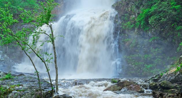
High Falls
- Difficulty
- Moderate
- Distance
- 1.2 ml
- Duration
- 1 hr
- Ascent
- 200 ft
- Descent
- 200 ft
Pine Creek Road, Cullowhee, NC 28723
Accessibility: Trail
Beauty Rating: 10
Photo Rating: 7
River: West Fork Tuckasegee River
Watershed: Itsy-bitsy or ginormous
Type & Height: Two-section free fall over a massive cliff; the total height is about 100 feet
Landowner: Duke Energy
Canopy: Open
Waterfall GPS: N 35.2044, W -83.1600
Best Time of Year: Jan 01 - Dec 31
Hike Descriptions: From the upper trailhead, the hike begins at the gate on High Falls Trail. You’ll descend on the gravel road for just under 0.2 mile, then turn right on the obvious trail. The trail descends a little over 0.6 mile to the falls. It is well graded and easy to follow but is steep in places and has lots of steps.
From the lower trailhead, take the side road that forks to the right off Shoal Creek Mountain Road. It has an orange gate. You’ll cross Shoal Creek on an auto bridge at 0.1 mile and come to a fork at 0.2 mile. Go left and ascend gradually for 0.4 mile. The trail swings around a ridge, then descends gradually for over 1 mile to a side path on the right. The side path leads to a view of Rough Run Falls. From the side path, it’s another 0.3 mile to High Falls. When you get close to the falls, you’ll have to scramble along the rocks to reach the base.
Most of the lower trail is not on Duke Energy property. The landowners allow public access provided visitors follow these conditions: no four-wheelers or other motorized vehicles, no littering, no camping, no campfires of any kind, no fishing or hunting. In other words, conduct yourself as you would anytime you’re on another person’s property. Break these rules and access for everyone could be denied.
Directions to Location:
- To reach the upper trailhead from US 64 in Cashiers, drive 6.2 miles north on NC 107 and turn left on Pine Creek Road (marked as SR 1163 on the green sign and SR 1157 on the stop-sign post)
- Drive 1.9 miles and park on the right at Pines Recreation Area.To reach the lower trailhead from US 64 in Cashiers, drive 8 miles north on NC 107 and turn left on the unpaved Shoal Creek Mountain Road (SR 1158)
- Go less than 0.1 mile and park on the side of the road just beyond the side road that forks right.
Trails and Waterfalls can be dangerous; take no chances, only photos for memories. Read our Safety and Insider tips to have a safe, fun and enjoyable trip to Jackson County.
Leave No Trace — Seven Principles
1. Plan Ahead and Prepare
2. Travel and Camp on Durable Surfaces
3. Dispose of Waste Properly
4. Leave What You Find
5. Minimize Campfire Impacts
6. Respect Wildlife
7. Be Considerate of Other Visitors
For more details, visit www.lnt.org
©1999 by the Leave No Trace Center for Outdoor Ethics
Two-section Waterfall100 FeetRiver-fed