Waterfall
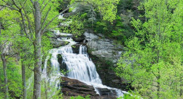
Cullasaja Falls
- Difficulty
- Easy
- Distance
- 0 ml
- Duration
- 0 hr
- Ascent
- 49 ft
- Descent
- 49 ft
U.S. Highway 64, Highlands, NC 28741
Accessibility: Roadside View
Beauty Rating: 9
Photo Rating: 7
River: Cullasaja River
Watershed: Medium
Type & Height: Long cascade totaling nearly 200 feet in height
Landowner: Nantahala NF, Nantahala RD
Canopy: Open
Waterfall GPS: N 35.1178, W -83.2707
Best Time of Year: Jan 01 - Dec 31
Overview: The Cullasaja River takes a final plunge over Cullasaja Falls before leaving the gorge and leveling out. What a final statement it makes! If the river’s up, this is about as good as it gets. On the other hand, I’ve seen it when little water was going over the falls, and it was hardly worth stopping for.
The section of US 64 paralleling the Cullasaja River through the gorge is one of the more scenic and spine-tingling roads in the state. After the road was completed in 1929, the Franklin Press called it “probably the greatest scenic highway in all the state.” Parts of the road were carved out of the sheer cliffs, with scarcely enough room for two vehicles to pass. A short distance west of Cullasaja Falls is the most hair-raising section of the road. You don’t want to meet a tractor-trailer in this stretch. I speak from experience.
The road makes Cullasaja Falls the most dangerous waterfall in North Carolina. When someone tells you to be careful at a waterfall, it usually means you shouldn’t do anything stupid that would cause you to fall. At Cullasaja Falls, it means watch out for the traffic! A narrow road, blind curves, sheer drop-offs, and waterfall gawkers don’t make a good combination. Exercise extreme caution here.
Cullasaja is the anglicized name for the Cherokee village Kulsetsiyi, which once stood near the river downstream from the waterfall. The Cherokee name translates to “honey locust place,” honey locust being a source of sweetener for the Cherokees. An English name for the village was Sugartown. For a time, the Cullasaja River was known as Sugar Fork.
Many publications state that Spanish explorer Hernando De Soto passed through Cullasaja Gorge during his 1540 expedition in search of gold. However, these assertions are based on information that has been disproved by historians. De Soto never came near the gorge. And even if he had, it’s highly unlikely he would have traveled through it. It’s hard enough to do it today in a car. In the first edition of this book, published in 1994, I perpetuated this myth. I’ve since learned to do a better job researching the facts.
Directions to Location:
- From NC 106 in Highlands, drive 8.75 miles west on US 64 to the pullout on the left
- You can view the falls from the road, but there is little room to pull over
- Also, it’s extremely dangerous to do so if you’re driving west because you have to cross traffic on a sharp curve
- It’s much safer to drive past the falls, turn around about 0.5 mile down the road, drive back, and then pull off.
Trails and Waterfalls can be dangerous; take no chances, only photos for memories. Read our Safety and Insider tips to have a safe, fun and enjoyable trip to Jackson County.
Leave No Trace — Seven Principles
1. Plan Ahead and Prepare
2. Travel and Camp on Durable Surfaces
3. Dispose of Waste Properly
4. Leave What You Find
5. Minimize Campfire Impacts
6. Respect Wildlife
7. Be Considerate of Other Visitors
For more details, visit www.lnt.org
©1999 by the Leave No Trace Center for Outdoor Ethics
Tall WaterfallRoadsideHistoric Significance